
Geographic Information System (GIS) Links and Data
The PIE LTER research program is involved with developing GIS datalayers and databases for the watersheds and waterbodies of the Plum Island Sound Estuary. GIS development has focused on understanding the impact of land use change on the watersheds in northeastern Massachusetts and the geomorphological evolution of tidal creeks in the Plum Island Sound Estuary.
Our GIS development has greatly benefited from the use of the Massachusetts Geographic Information System developed by the Commonwealth of Massachusetts Office of Geographic and Environmental Information. Databases and datalayers have been developed by colleagues at Clark University, The University of New Hampshire and The Marine Biological Lab.
Clark University (GIS)
There are two faculty members at Clark University who are members of the PIE research team. They are Robert Gilmore Pontius Jr (rpontius at clarku.edu) and Colin Polsky (cpolsky at fau.edu). Since 1999, Pontius and his students have been creating GIS-based methods for land change prediction. They develop novel techniques of model validation and land change assessment. Much of their work can be found at www.clarku.edu/~rpontius. Most of the maps below were obtained from the Massachusetts Geographic Information System and formatted to facilitate simulation modeling of changes among land cover types over time. Future scenarios of land change are used to make scenarios of nutrient loading. Polsky and his students study the vulnerability of human populations to the possible over-exploitation of water and land.
Clark University contributed GIS data for the Ipswich and Parker watersheds which have been developed in IDRISI with most files raster based. Many will open using ArcGIS 10.x; please contact us if you have questions.
Updated June, 2013: Files are now downloadable in zip files which include all necessary GIS files, original FGDC metadata Word documents, and EML-compliant metadata in XML format.
Clark University, holmes (HERO object-based Lawn Mapping Exploration of Suburbia) group, is focused on producing very high resolution (.45 m) maps of the Plum Island Ecosystem. The group is advancing object-oriented methods for mapping, focusing on issues of accuracy assessment and methodological comparison. holmes is a subgroup of the HERO project. holmes was created in September 2006, when two geography 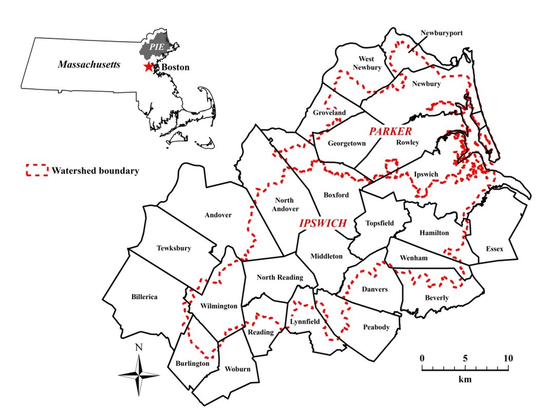 professors at Clark University (Colin Polsky and Gil Pontius) recognized the need for a high-resolution dataset to fostercollaborative research with two ecologists (Chuck Hopkinson and Wil Wollheim). That discussion formed the basis for a successful, $1.4M grant proposal to NSF’s Coupled Natural-Human Systems competition, submitted in November 2006 and awarded in May 2007. This project usesthe premise described above about suburbanization to examine social dynamics, ecological dynamics, and coupled socio-ecological dynamics.
For more info see: The George Perkins Marsh Institute (GPMI) Working Paper, 2012-24: HERO Object-based Lawn MappingExploration of Suburbia: Rationale, Methods and Results for the NSF Plum
Island Ecosystems Long-Term Ecological Research Site [pdf]. Colin Polsky, Robert Gilmore Pontius, Jr., Nicholas M. Giner, Albert Decatur, Daniel Miller Runfola, and Rahul Rakshit, Clark University, December
2012.
University of New Hampshire River GIS
University of New Hampshire researchers are developing river network hydrological and biogeochemical models to explore how land use change, climate variability and change, and surface water management affect water and nutrient fluxes throughout the basin and to the estuary. A central requirement for this model is a digital river network that is used to simulate surface water flow paths from source areas to the coastal zone. The river network is grid-based at a 120m by 120m resolution. The gridded river network is used to explore scientific questions regarding the role of different land uses in defining nutrient loading, and the role of river systems in controlling exports to the coastal zone.
Links to additional GIS Information
Massachusetts Geographic Information System -- Mass GIS data direct data access
- Massachusetts Interactive Property Map - Lot/parcel and property owner information available by address or zooming in on map of Massachusetts, based on town assessors infomation.
Massachusetts Electronic Atlas -- Harvard University Geospatial Library
USGS Earth Explorer -- Comprehensive remote sensing product access