
Watersheds
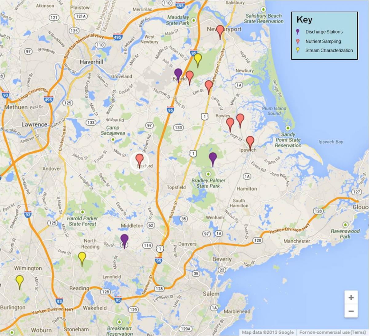 Three watersheds comprise the Plum Island Sound land margin ecosystem: the Parker River (155 km2), the Rowley (26 km2) and the Ipswich (404 km2).
The Parker River watershed is largely undisturbed with extensive
upland, bottomland hardwood and cedar swamp forests. Almost 50% of the
Parker River watershed is set aside as conservation land. The basin
contains some minor rural-residential development. There is a single
minor industrial development and there are no major cities.
The
Rowley River watershed is small and drains directly into Plum Island
Sound. The river has one wastewater discharge site and no mainstem dams.
This watershed is entirely low lying coastal plain and predominantly
salt marsh. There is some rural-residential development within the upper
watershed.
The
Ipswich River watershed is the largest and most developed. The
watershed is primarily coastal plain. There are three mainstem dams, one
major water treatment plant in the town of Peabody as well as eight
smaller wastewater discharge sites.
Almost
25% of the Ipswich watershed is set aside as conservation land, the
rest is primarily suburban-residential. Boston bedroom communities have
been rapidly encroaching along the southern portion of the watershed.
The USGS maintains two gauging stations on the Ipswich. The one at the
mouth of the river has a mean discharge of 249 cfs. Dam samples from the
Parker River and Ipswich River have been taken approximately monthly
since 1993, and at the Egypt River since 1999 to determine loading to
the Plum Island estuarine system from the watershed.
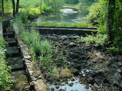
Parker River Dam, off River St., Newbury, MA during a low flow
(point mouse over for high flow)
photos by Wil Wollheim
Benthic
Benthic
sampling sites fall into two categories. Some sites have been sampled
for studies of benthic metabolism as well as for porewater and solid
phase analyses; data from these metabolism studies may be found in the
“flux” file (BEN-PR-Flux).
Porewater and solid phase data from these sites plus additional sites may be found in the “sediment” files (BEN-PR-Sed-Porewater and BEN-PR-Sed-Solids).
Since
1993, we have sampled a total of four flux stations in the Parker River
and one at the mouth of the Rowley River in Plum Island Sound. Some
sites have been visited repeatedly, whereas others may have been sampled
only once. In 2000 we also sampled three flux stations in the Egypt
River, an upper fork of the Rowley River.
On
a transect from the mouth of Plum Island Sound to the head of the
Parker River, the five stations occur as follows. Station R5.5
(previously called Station Rowley) is located on a sand flat just
outside the mouth of the Rowley River in Plum Island Sound on Hog Island
Point, 5.5 km from the mouth of the Sound. Station R5.5 is one of our
long-term monitoring sites. This station is in a very dynamic, high
salinity region (25-34 psu) and has sediments composed almost
exclusively of sand. Ripples about 10 cm long attest to the strength of
the tidal currents in this area, which are of sufficient magnitude to
create sand waves 10-20 m long. Station R5.5 is representative of the
very large benthic area covered by Plum Island Sound (> 6 km2),
and is strongly influenced by oceanic input. The nextflux station
upstream is Station P14 (formerly P5), located about 14 km from the
mouth of the Sound and just downstream of the confluence of the Mill
River with the Parker River. Sediments at Station P14 are silt/clay and
fine sand, and support high densities of the soft-shelled clam, Mya arenaria,
as well as other infauna. We consider Station P14 to be a mid-salinity
station, where salinity may range from as low as8 psu up to 32 psu over
the course of the year, depending on freshwater discharge. Station P22 is 22.25 km upstream, or about 1.7 km downstream of the dam at the head
of the estuarine portion of the Parker River. Station P22 has been the
most frequently visited station in the Parker River and is another of
our long-term monitoring sites. It is located in the oligohaline portion
of the estuary, with salinity typically ranging from 0 psu to nearly
20psu during mid to late summer when freshwater input is lowest.
Sediments here are muddy silts andclays. The intertidal banks at this
site are colonized by benthic diatoms. However, few large infauna are
present. In 1996, we sampled an additional station in the upper Parker,
Station 23.5.
 Additional
sites that have been used to collect samples for porewater and solid
phase sediment data are Stations P11 and P24 on the Parker River. Station
P11, formerly referred to as “Town Landing” due to its proximity to the
Town of Newbury's public boat ramp, is in the lower reach of the parker
River, only 10.7 km upstream of the mouth of the Sound. Salinity ranges
from over 20 psu to full strength seawater at this site, and sediments
are coarse to fine sands and silts. Station P24 is at the uppermost end of the estuarine portion of the Parker River,
just below the dam. Salinity is typically less than 5 psu at this site,
but may reach 15 psu or more when freshwater input is minimal.
Sediments are fine silt/clays, similar to those at P22.
The
three sites sampled for nutrient flux studies in the Egypt River are
Stations E13, E13.5, and E14, located 13, 13.5, and 14 km, respectively,
upstream from the mouth of the Sound. The Egypt/Rowley Rivers receive
less freshwater input than does the Parker River.High tide salinities
under normally low freshwater discharge are about 15, 10 and 7 psu,
respectively. However, in 2000,discharge was unusually high and high
tide salinities dropped to 5, 3, and <2 psu. Sediments at Stations
E13 and E13.5 are peaty with silts and some sand, and those at P14 are
somewhat sandier. The intertidal banks at E13 and E13.5 support high
densities of benthic diatoms. In contrast to stations in the upper
reaches of the Parker River, all three Egypt River stations support a
diverse fauna, including the active bioturbator Nereis diversicolor.
Marsh
PIE-LTER has established three plot-level fertilization sites: a Typha dominated site in the upper Parker River Estuary and two sites on Law's Point in the Rowley River Estuary, one dominated by Spartina patens and the other by Spartina alterniflora.
Six marsh transects have also been sampled in the Rowley River Estuary,
with each transect originally having three sampling locations (x.1,
x.2, x.3, with increasing distance from Rowley River Estuary):
- Holy Island
- Morris Island
- Law's Point
- Infilling Pond
- Sweeney Creek
- Levine Marsh
Several
benchmarks have also been established within the Plum Island marsh
system, near the Rowley Field House, on Law's Point, and on Holy Island.
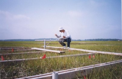
 USC Graduate Student, Rob Daoust, measuring surface RA Samantha Bond measuring surface elevation
elevation at the Law's Point fertilization plot. at one of the Levine Marsh Plot
USC Graduate Student, Rob Daoust, measuring surface RA Samantha Bond measuring surface elevation
elevation at the Law's Point fertilization plot. at one of the Levine Marsh Plot